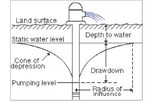
HARTINGTON — The static water levels of 34 irrigation wells located throughout the Lewis and Clark Natural Resources District are measured in the spring and fall each year. Groundwater levels measured this spring indicate a decline in 19 of the 34 wells monitored.
There are multiple aquifers across LCNRD from where water is pumped for irrigation use, including widely distributed sand and gravel, Missouri River Alluvium, Niobrara Bedrock and Dakota Sandstone aquifers.
In the sand and gravel aquifers 13 of the 22 wells monitored showed a decrease in water levels compared to spring of 2024, where the average decline was 0.2 feet.
Half of the wells monitored in the Missouri River Alluvium were up and half were down, with an average increase of 0.1 feet from the spring of 2024. Wells in the Missouri River Alluvium typically reflect water levels in the Missouri River.
Four of the five wells in the Niobrara Bedrock Aquifer showed decreased water levels, with the average being 1.5 feet lower.
The deeply buried Dakota Sandstone Aquifer showed an average increase of 0.2 feet. Recharge impacts to the Dakota Sandstone Aquifer can take several years to be reflected in the water levels.
Most of the 2024 spring water levels showed little change compared to recent years. The average water level for the spring of 2025, considering all wells measured, is 0.8 feet lower than the spring of 2013 readings, which was the first year after the 2012 drought.
Groundwater levels of irrigation wells are monitored and recorded by LCNRD to monitor fluctuations in water levels. A downward trend observed over a period of five years or a significant decline over two years is considered cause for concern. Timely rainfall and decreased demand for irrigation can have a positive impact on water levels. Adopting wise irrigation practices is important to maximizing crop yields and ensuring sustainable groundwater levels.

.jpg)


